Sydney to Adelaide is about 1,412 km and 17 hours of driving by the inland Sturt Highway, through Wagga Wagga, Hay, Balranald, Mildura and Renmark, by OSRM routing. The other options are the Hume Highway via Melbourne, about 1,591 km, and the remote Barrier Highway through Cobar and Broken Hill, which is a longer outback drive.
Sydney to Adelaide routes compared
The inland route follows the Hume Highway from Sydney to Tarcutta, then the Sturt Highway through Wagga Wagga, Narrandera, Hay, Balranald, Mildura, Renmark and Waikerie to Gawler and Adelaide. Wikipedia says the Sturt Highway runs 947 km from Tarcutta to Gawler, about 596 km in New South Wales, 117 km in Victoria and 234 km in South Australia, and that most of it is single carriageway. The second option is the Hume Highway to Melbourne, then the Melbourne to Adelaide road, which the coastal route guide covers. The third is the Barrier Highway, which leaves the Mitchell Highway at Nyngan and runs through Cobar, Wilcannia, Broken Hill and Yunta to Burra.
All distances and times are from OSRM routing on OpenStreetMap data, checked on 3 November 2026, for a car with no stops. By that routing the Barrier Highway route is about 1,673 km. Wikipedia gives the Barrier Highway as 1,012 km from Nyngan to Giles Corner in South Australia.
| Route | Distance | Drive time | Road | Best for |
|---|---|---|---|---|
| Hume and Sturt Highways via Hay and Mildura | About 1,412 km | About 17 h 18 min | Hume dual carriageway, then mostly single carriageway | The shortest drive, river towns and the Riverland |
| Hume Highway via Melbourne | About 1,591 km | About 19 h 28 min | Dual carriageway to Melbourne, then the Melbourne to Adelaide road | A Melbourne night, then the coast |
| Barrier Highway via Cobar and Broken Hill | About 1,673 km | About 21 h 18 min | Remote, sparsely settled, fully sealed since 1972 | Outback drivers who want Broken Hill |
- Sturt: shortest, single carriageway
- Via Melbourne: dual carriageway most of the way
- Barrier: remote, long fuel legs
Sydney to Adelaide on the Sturt Highway in four days
By OSRM routing, a four-day split is Sydney to Wagga Wagga about 455 km (5 h 29 min), Wagga Wagga to Hay about 269 km (3 h 19 min), Hay to Mildura about 292 km (3 h 32 min) and Mildura to Adelaide about 397 km (4 h 57 min). Along the way, Goulburn is about 194 km from Sydney, Gundagai about 181 km further, Narrandera about 97 km after Wagga Wagga, Balranald about 135 km after Hay and Renmark about 143 km after Mildura.
The Hume Highway part is dual carriageway and 110 km/h, and the Sturt Highway beyond Wagga Wagga is where the quieter, single carriageway driving starts.
- Wagga Wagga about 455 km
- Hay about 724 km
- Mildura about 1,016 km
Where to stop on the Sturt Highway
Wagga Wagga has BIG4 Wagga Wagga Holiday Park. Narrandera has Sandy Beach campground at Cudgel in the AussieCamps data, and Narrandera Visitors Centre rest area for a break. Hay Caravan Park is on the Sturt Highway about 1 km east of the Sturt and Cobb Highway junction, and Hay Shire's directory also lists Hay Plains Holiday Park on Nailor Street and Hay Showground Caravan and Camping Ground on Showground Road. Balranald Lions Park is a rest area with toilets, shelter, picnic tables and barbecues in the AussieCamps data.
At the Victorian border, Discovery Parks Mildura Buronga Riverside is at 71A Caravan Park Road, Buronga, and has cabins, powered and unpowered sites and a dump point. In the Riverland, Discovery Parks Renmark Riverfront is at 1 Patey Drive, Renmark. The AussieCamps data lists Loch Luna, Kaiser Strip and Moorook campgrounds nearby. Check availability with each park. Rest areas are for a break: New South Wales advice conflicts, and South Australia and Victoria have no statewide limit in the sources checked, so read the sign and the rest area guide.
- Hay: three parks to choose from
- Mildura: Buronga on the NSW side
- Riverland campgrounds in the data
The Barrier Highway option
For the remote route, Rita's Outback Guide gives leg distances of Nyngan to Cobar 132 km, Cobar to Wilcannia 261 km, Wilcannia to Broken Hill 198 km, Broken Hill to Yunta 195 km and Yunta to Burra 159 km. Sydney to Dubbo is about 398 km and Dubbo to Nyngan about 165 km by OSRM. Cobar Caravan Park is at 101 Marshall Street in Cobar and Broken Hill Tourist Park has cabins, powered sites and a dump point, listed by the operator.
Wikipedia describes the area as remote and very sparsely settled. NSW National Parks says outback NSW has extreme temperatures, reaching up to 50 degrees Celsius in some places, with autumn and spring the best times for long drives, and says to stay with your vehicle if it breaks down. The road trains guide covers road train etiquette.
- Cobar to Wilcannia 261 km
- Wilcannia to Broken Hill 198 km
- Stay with the vehicle if it breaks down
Fuel and services
On the Barrier Highway, Rita's Outback Guide describes Emmdale Roadhouse as the only place to get fuel between Cobar and Wilcannia, and Little Topar Roadhouse as the only place for fuel, drinks and food between Wilcannia and Broken Hill. Opening hours and whether Little Topar is currently trading could not be confirmed, so ring ahead. Nyngan, Cobar and Wilcannia are towns with fuel, and Yunta has two fuel stations according to the same guide. NSW National Parks says Mutawintji National Park, a side trip from Broken Hill, has no fuel or food.
On the Sturt Highway the longest town-to-town legs are Narrandera to Hay at about 175 km and Balranald to Mildura at about 159 km by OSRM. Fuel at smaller towns such as Darlington Point, Carrathool, Oxley and Euston could not be confirmed, so fill up at Wagga Wagga, Narrandera, Hay, Balranald and Mildura. The fuel planning guide shows how to budget the distance.
- Barrier: fuel before Cobar and Wilcannia
- Sturt: fill up in Narrandera, Hay and Balranald
- Ring ahead for roadhouse hours
Road conditions, tolls and heat
Check Live Traffic NSW (livetraffic.com), VicTraffic and, in South Australia, the DIT outback road closures page (1300 361 033). The SA page says closed outback areas are restricted to residents, landowners, accredited media and relief services and not to try to travel through affected areas. A Riverina story reported the Sturt Highway west of Hay closing to light vehicles when the Murrumbidgee spilled over it, but it is undated, so check flood status before leaving.
Sydney's M5 and M7 are tolled and meet the Hume at Prestons. Linkt says that without an account you can buy a pass within 5 days of your first trip on Sydney or Queensland toll roads, and that unpaid trips bring a notice and an admin fee to the registered owner. Transport for NSW warns drivers in heatwaves to allow extra time because high temperatures often cause more breakdowns.
- Live Traffic NSW and DIT outback closures
- Check flood status near Hay
- Heat breaks vehicles down
Border rules: South Australia's fruit fly zone
South Australia is the border to plan for. PIRSA says there are permanent restrictions on bringing host produce into South Australia and the Riverland Pest Free Area, as well as restrictions within declared fruit fly outbreak areas. Quarantine bins are available at key entry points into South Australia and the Riverland, and it says travellers carrying restricted items should eat them beforehand or dispose of them in the bins. PIRSA also says it puts random roadblocks in place with quarantine officers checking vehicles for fresh fruit and vegetables, and that travellers found carrying restricted items may face a fine. The fine rose on 1 July 2026, so check the current amount on the PIRSA site.
Restricted produce can move if it is canned, cooked, dried, frozen, grated or pureed. The Interstate Quarantine site says for the Riverland not to take fresh, unprocessed fruit or fruiting vegetables. Outbreak areas and end dates change, so use the PIRSA outbreak map and the Fruit Fly Hotline on 1300 666 010. In Victoria, Agriculture Victoria says the Greater Sunraysia Pest Free Area regulation lapsed in July 2024 and Mediterranean fruit fly restrictions still apply statewide. The interstate biosecurity guide has the full picture.
- Eat or bin fresh fruit and vegetables before South Australia
- Canned, cooked, dried, frozen: allowed
- Fruit Fly Hotline: 1300 666 010
Dump points and the clock changes
The AussieCamps data lists dump points on the Sturt route at Ampol Foodary Pheasants Nest Southbound (no washout tap listed), Uranquinty Rest Area (no washout tap listed), Lions Park in Darlington Point (washout tap listed) and Greenock Centenary Park in South Australia (washout tap listed). On the Barrier route it lists Farrell Flat Dump Point in South Australia (washout tap listed), and the operators of Discovery Parks Mildura Buronga Riverside and Broken Hill Tourist Park also list dump points. That is not every dump point, so check the dump points guide.
Daylight saving began on Sunday 4 October 2026 in New South Wales, Victoria, South Australia, Tasmania and the ACT, and ends on Sunday 4 April 2027. South Australia is on central time, so it is half an hour behind Victoria and New South Wales while daylight saving runs, and your clock goes back 30 minutes when you cross near Renmark. Broken Hill is in New South Wales but keeps Australian Central time.
- Washout tap listed at Darlington Point and Greenock
- SA is 30 minutes behind Victoria until 4 April 2027
Plan the Sydney to Adelaide drive in AussieCamps
Add the overnight stops to a trip in AussieCamps and it lists them in order with the distance and drive time of each leg, and the forecast for the day you plan to arrive. AussieCamps lists 1,838 campgrounds, 5,552 rest areas and 1,393 dump points from park agencies, road authorities and public datasets, and a place page shows the facilities those sources publish. Save a collection of stops for the Sturt Highway and another for the Barrier Highway to compare them.
Stored place details, saved places and guides work with no signal. Map tiles, routing, weather and photos need a connection, so open the trip before the long legs between Wagga Wagga and Mildura. AussieCamps runs on iPhone only, and it is free to download, with in-app purchases.
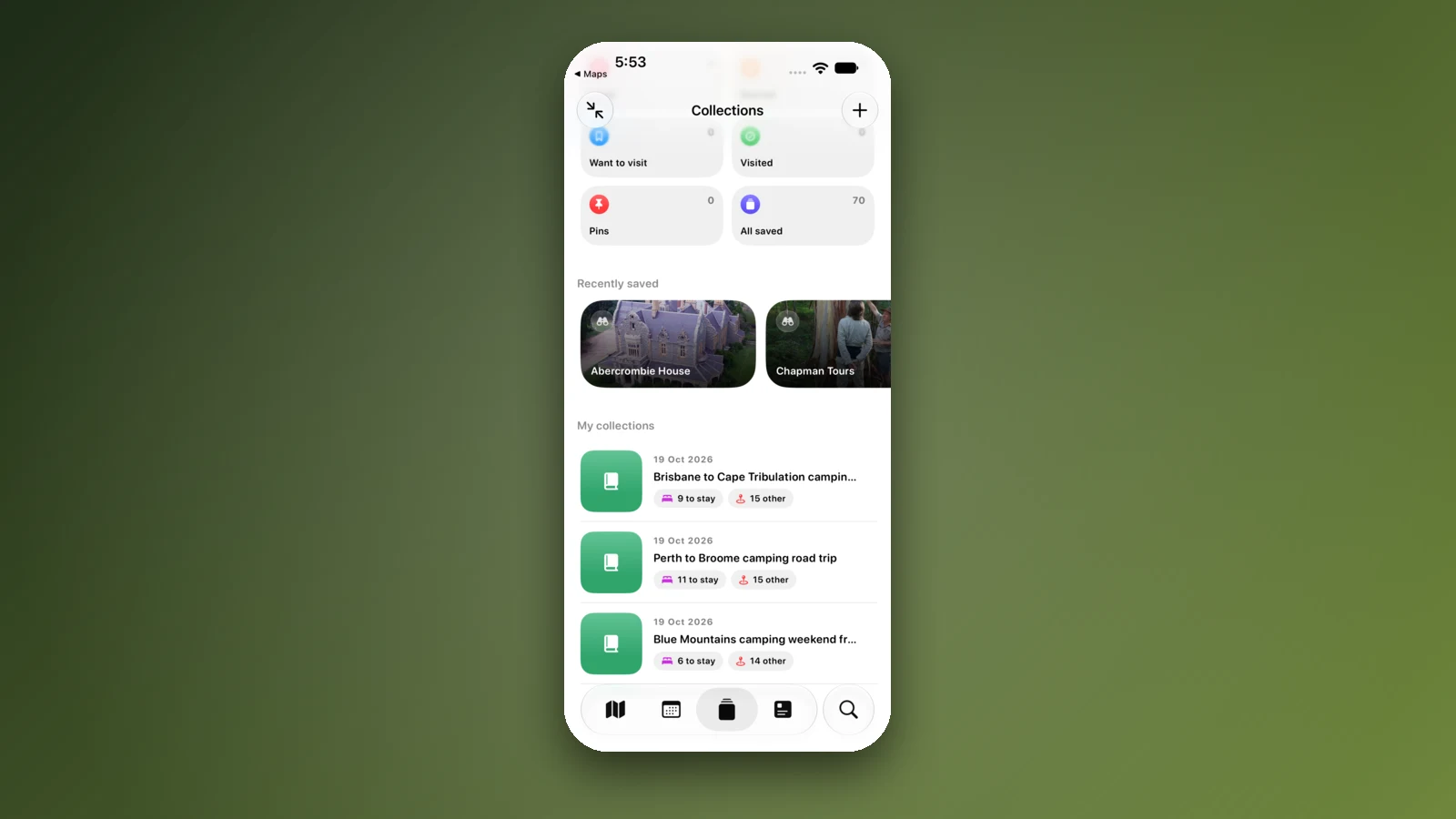
- Save a collection per route
- Leg times and a forecast per stop
- Open the trip before the long legs
Places along the way
Check before you go
Rules and conditions change. Recheck the official source and the page for your exact park or campground before departure.
- OSRM routing on OpenStreetMap data (Sydney to Adelaide, checked 3 November 2026)
- Wikipedia: Sturt Highway
- Wikipedia: Barrier Highway
- Rita's Outback Guide: Barrier Highway
- NSW National Parks: outback safety
- PIRSA: South Australian fruit fly
- Interstate Quarantine: quarantine zones
- Agriculture Victoria: regulatory changes in the Greater Sunraysia region
- SA Department for Infrastructure and Transport: outback road closures
- Linkt: travelling interstate
- NSW Government: daylight saving in NSW
- Live Traffic NSW
- Hay Shire Council: caravan parks
Common questions
How far is it to drive from Sydney to Adelaide?+
About 1,412 km and 17 h 18 min by the inland Sturt Highway route, or about 1,591 km and 19 h 28 min by way of Melbourne, by OSRM routing on OpenStreetMap data. Plan three or four days.
Which is the shortest road from Sydney to Adelaide?+
Wikipedia calls the Sturt Highway, reached by the Hume Highway to Tarcutta, the shortest, highest-standard route between the two cities. It runs 947 km from Tarcutta to Gawler through Narrandera, Hay, Balranald, Mildura and Renmark, and most of it is single carriageway.
Can I bring fruit into South Australia?+
Not fresh fruit and fruiting vegetables in most cases. PIRSA says there are permanent restrictions on bringing host produce into South Australia and the Riverland Pest Free Area, and quarantine bins and random roadblocks operate at entry points. Produce that is canned, cooked, dried, frozen, grated or pureed can move, so eat or bin fresh produce before you cross.
Is Broken Hill on a different time to Sydney?+
Yes. Broken Hill is in New South Wales but uses Australian Central time, so it is half an hour behind Sydney while daylight saving runs. On the Sturt Highway route, South Australia is also half an hour behind Victoria and New South Wales until daylight saving ends on 4 April 2027.
Take it on the road
Save the stops. Plan the whole trip.
Build an ordered route from saved places, calculate the distance and keep dates, notes and to-dos attached.